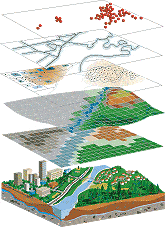
Guardian Medical Transport uses Geographic Information Systems mapping, or GIS, in many aspects of our response. Using GIS, we can store a collection of smart map layers to be used with multiple software applications in a central database. Smart map layers are points, lines, or polygons with tables of attributes connected. These drive the display or cartography of maps so we can quickly compose maps, display geography and perform quick analysis.
GIS databases are maintained and shared in cooperation with Coconino County, the City of Flagstaff, the State of Arizona and other governmental agencies. Using these databases of smart map layers, street addresses can be geocoded along with Global Positioning System coordinates, or GPS, which provide a point on a detailed map within the Computer Aided Dispatch System, or CAD, to help dispatch the closest unit that also uses GPS to display their location on the same map. All dispatch information is also provided on mobile devices to better communicate details to all first responders.
NAH’s Guardian Medical Transport has shared responsibilities concerning emergency response with city, county and state government agencies during wildfire incidents. Guardian Medical Transport has a Geographic Information Systems (GIS) Mapping Specialist who is a member of a national Incident Management Team (IMT), which manages rapidly spreading and complex wildland fires and other multi-hazard incidents using Incident Command Structure (ICS). In the last several years the GIS Mapping Specialist has worked on IMTs for the 2019 Museum, 2021 Rafael, 2022 Tunnel and 2023 Cecil Fires, in addition to many other wildland fires around the western United States. Wildland fire incidents are searchable and listed at InciWeb.
For more details about GIS and Wildland Fire please visit Ponderosa Fire Advisory Council (PFAC), of which Guardian Medical Transport is a partner agency.
